Log. Plan. Shoot.

The ultimate location tracking app for photographers. Document your favorite shooting spots, plan your next photo, and never forget where you captured that perfect moment.

Now available on the App Store! Download on the App Store

Free to try (limited to 20 locations). Unlimited locations are a one-time $3.99 purchase — no subscription.

📍 GPS Tracking 🌅 Astronomical Data 🔒 Privacy First ☁️ iCloud Backup
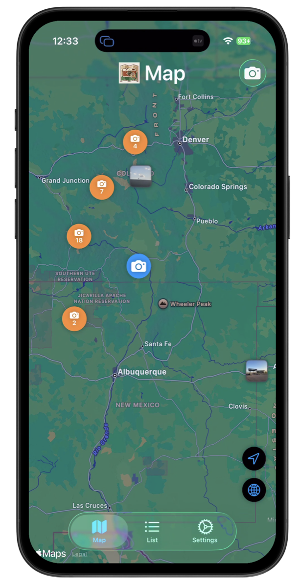
Photography location tracking app showing interactive map with GPS photo locations, landscape photography spots, and astrophotography sites

Essential Tools for Photography Planning

Everything photographers need to document, plan, and share shooting locations

🗺️

Interactive Map View

Visualize and navigate to all your favorite shooting locations on an interactive map. Plan future shoots and discover new perspectives. Multiple map styles (Standard, Hybrid, Satellite) help you scout terrain and plan compositions.

🌅

Astronomical Planning Data

Plan the perfect shot with sunrise/sunset times, moonrise/moonset schedules, and Milky Way core visibility. Essential astronomical data helps you time your shoots for optimal lighting and celestial conditions.

🏷️

Smart Tagging & Organization

Organize your shooting locations with custom tags like 'golden-hour,' 'landscape,' or 'milky-way.' Autocomplete suggestions and recent tags make categorization effortless. Search by location name, tags, or description to quickly find that perfect sunset spot.

🤝

Share with Fellow Photographers

Found an amazing shooting location? Share it with your closest photography friends. Send exact GPS coordinates, reference photos, and notes about best times to shoot. Perfect for photography workshops, location scouting, or sharing hidden gems.

☁️

Automatic iCloud Backup

Toggle automatic backups on/off in Settings. You decide how many backups the app retains. Manual backup and restore options available. Never lose your location data.

🌍

Export to KML (Google Earth)

Export your shooting locations to KML format for use in Google Earth, Google Maps, or professional GIS software. Perfect for planning expeditions, creating location guides, or analyzing your photography patterns across regions.

From Location Scout to Perfect Shot

Your complete workflow for photography location management

1

Scout & Capture

Discover a great location and snap a reference photo. GPS coordinates are automatically recorded, so you'll always know exactly where you were.

2

Add Planning Details

Tag locations by genre (landscape, portrait, milky-way), add notes about best shooting times, and track when you want to return.

3

Plan Your Shoots

Check astronomical data for sunrise/sunset times, golden hour, and Milky Way visibility. Plan the perfect time to return for that ideal shot.

4

Share & Revisit

Share favorite spots with photography friends or export to Google Earth for trip planning. Your shooting locations are always at your fingertips.

Built for Photographers, Trusted by Professionals

From landscape to astrophotography, supporting every photography genre

📸 Landscape & Nature Photography

Document shooting locations across seasons. Track sunrise/sunset times, moon phases, and Milky Way visibility for each spot. Build a personal database of locations with notes about best conditions, lighting, and compositions.

🌌 Astrophotography Planning

Log dark sky locations and track Milky Way core positions. Plan shoots around moon phases and astronomical events. Save coordinates of low-light-pollution spots for return visits.

🏙️ Urban & Street Photography

Remember that perfect alley with amazing light at 4 PM. Document street art locations, architectural features, and unique urban perspectives. Share hidden photo spots with your local photography community.

✈️ Travel Photography

Log breathtaking viewpoints during travels. Remember where you took that stunning sunset shot in Santorini or that perfect wildlife moment in Tanzania. Build a global map of your photographic adventures.

🔬 Field Research & Documentation

Mark research sites, track data collection points, and share with team members. Export to GIS tools for scientific analysis. Perfect for environmental studies and data collection.

🏗️ Professional Documentation

Construction sites, real estate properties, inspection points, and client location management. Document and organize professional work locations efficiently.

What Fake Users Are Saying 😄

Real reviews are rolling in now that we're live — if you're using the app, we'd love to hear what you think! Let us know.

⭐⭐⭐⭐⭐

"The astronomical data feature is a game-changer. I can see exactly when the Milky Way will be visible at my favorite locations. No more guessing!"

— Astrophotographer, Colorado

⭐⭐⭐⭐⭐

"As a landscape photographer, I'm always searching for new locations. This app helps me remember every spot, plan return visits, and share gems with my workshop students."

— Professional Landscape Photographer

⭐⭐⭐⭐⭐

"Finally, an app built specifically for photographers. The combination of location tracking and astronomical planning saves me hours of research."

— Travel Photographer

Support & Help

Guides, answers, and a real person on the other end of the email

📖

User Guide

The complete manual — logging your first location, planning shoots with astronomical data, sharing, exporting to Google Earth, and backing up your library. Thirteen chapters, all searchable.

Read the User Guide →
✉️

Email Support

Question the guide doesn't answer? Send us a note. We read every message and typically reply within two business days.

info@myphotologpro.app →
🐞

Report a Bug or Request a Feature

Found something broken, or thought of something the app should do? Tell us what happened, which build you're on, and what you expected instead.

Send a report →

Frequently Asked Questions

The questions we get asked most often

Does MyPhotoLog Pro work offline?

Yes. All your photos, locations, tags, and notes are stored directly on your device, so your full library is available with no internet connection — which matters when you're deep in a canyon with no signal. Map tiles and optional iCloud backup are the only parts that need connectivity.

How accurate is the GPS, and how does the app know which way I was pointing?

The app records GPS coordinates from your device and reads the compass to capture the direction your camera was facing. A compass indicator on the camera screen shows you how reliable that reading is: green means it's solid, yellow is acceptable, and red means the sensor is struggling. If it's red, move away from vehicles or metal tripod legs and trace a slow figure-8 in the air with your phone — that usually recalibrates it in seconds.

What does the astronomical data actually tell me?

For any saved location and any date you pick, you get sunrise and sunset times with their compass directions, golden hour and blue hour windows, moonrise and moonset with phase and illumination percentage, and Milky Way core rise, zenith, and set times with the best viewing window. It also shows elevation, distance to the horizon, and magnetic declination. All times are calculated in the local timezone of the saved location. Full details in the guide →

Can I log a spot without taking a photo?

Yes, and it's one of the most useful things the app does. Press and hold anywhere on the map to drop a pin, or search for a place by name and save the result. Either way you can name it, assign a type — Campsite, Trailhead, Viewpoint, Parking, and more — and add notes. Handy for marking a trailhead you spotted on satellite view but haven't visited yet.

How do I share locations with other photographers?

Open any location and tap "Share Photo Location" to export a .myphotolog file containing the photo, coordinates, tags, notes, and location type. Send it by AirDrop, Mail, Messages, or anything else in the iOS share sheet. To send several at once, press and hold a location in the List view to enter selection mode and pick the rest. The recipient needs MyPhotoLog Pro installed to open it. More on sharing →

Can I export to Google Earth or my Garmin GPS?

Both. Settings > Data & Sharing > Google Earth exports your whole library as a .kml file that opens in Google Earth, Google Earth Pro, or Google Maps — and you can import KML files from other sources the same way. For a single waypoint, tap "Share GPX Waypoint" on any location detail screen to get a .gpx file for Garmin Connect, AllTrails, or any standard GPS app.

What gets backed up, and how do I restore?

A full backup captures everything: photos and location data, custom location types, your icon and color customizations, and all app settings. Automatic iCloud backup is on by default and runs whenever the app moves to the background, keeping your three most recent backups. You can also export a manual backup from Settings > Data & Sharing > Backup & Restore. Note that restoring replaces your current photos and settings, so be sure that's what you want. Backup guide →

I'm getting a new iPhone. How do I move my library?

Create a manual backup on your old device first (Settings > Data & Sharing > Backup & Restore > Export Backup), transfer the file to the new phone, then import it there. Your complete setup comes across intact — every location, custom type, and setting, not just the photos.

Is my photo and location data private?

Your app data stays on your device. We don't operate a server that receives your photos, coordinates, notes, or tags, and we can't see any of it. Optional iCloud backup goes directly to your own iCloud account. Data leaves your device only when you explicitly share or export it — with one optional exception, an elevation lookup that is off by default. Read the full privacy policy for details, including what the website itself collects.

How much does MyPhotoLog Pro cost?

The app is free, and the free version includes every planning feature: sun, moon, and Milky Way data, compass direction, custom location types, tagging, search, coordinate copying, KML export, GPX waypoints, sharing your locations with others, and full iCloud backup and restore. The only limit is how many locations you can save — 20. Unlimited locations are a one-time $3.99 purchase, which also unlocks bulk importing: KML files, shared collections, and migration from the older MapAPic app. There is no subscription and nothing expires. The three sample landmarks don't count toward your 20, and restoring your own backup is never restricted. Full breakdown in the guide →

Where can I get MyPhotoLog Pro?

MyPhotoLog Pro is available now on the App Store — download it here, or scan the QR code above with your iPhone camera.

Didn't find what you needed? Email us directly — we're happy to help.

Ready to Elevate Your Photography Workflow?

Join photographers worldwide who never miss the perfect light at their favorite locations. Download MyPhotoLog Pro and start building your personal shooting location database today.

Download on the App Store

Free to download. One-time $3.99 upgrade for unlimited locations — no subscription.

QR code linking to MyPhotoLog Pro on the App Store Scan to download